MOERS (DE) - 2011-01-05 08:33:42
- Magnitude 3.1
Last update : 2016-11-24 12:09:24 Belgian time
Main parameters
| Date and time |
2011-01-05 08:33:42 UTC
2011-01-05 09:33:42 Belgian time |
| Type | Known induced event |
| Magnitude | ML 3.1 |
| Maximal intensity | IV |
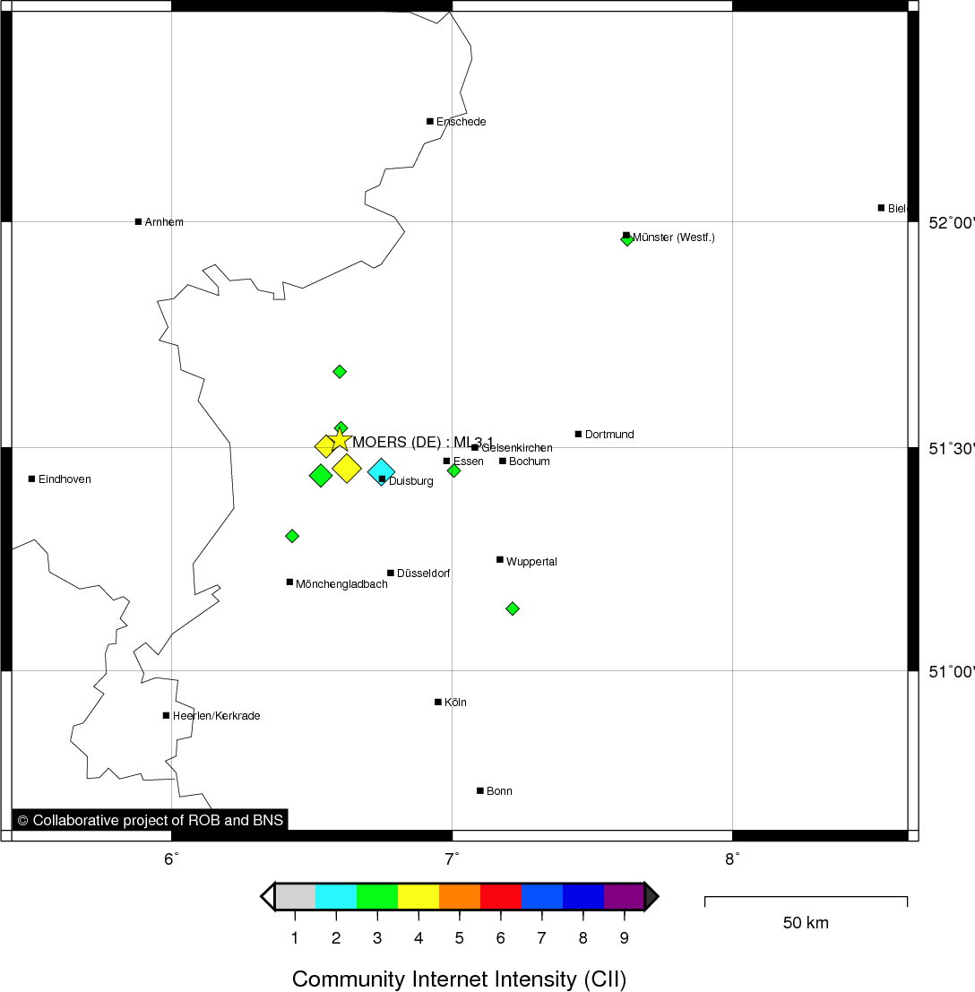
| Region | MOERS (DE) |
| Epicentral coordinates | 51.517° N, 6.599° E Uncertainty ± 3.2 km |
| Depth of hypocenter | 6.6 ± 4.0 km |
Data source : ROB (Royal Observatory of Belgium)
Location map
Quake measurements
Measurements by the Belgian seismic network
| Station | Epicentral distance (km) |
P-Wave arrival (hh:mm:ss.ss) | S-Wave arrival (hh:mm:ss.ss) | Maximal ground displacement (nm) |
|
|---|---|---|---|---|---|
| Code | Place | ||||
| HRK | HERKENBOSCH | 47 | 08:33:50.37 | 08:33:56.23 | 235.5 |
| MEMS | MEMBACH | 109 | 08:34:00.04 | 08:34:14.31 | 568.1 |
| EBN | EBEN-EMAEL | 103 | 08:34:00.34 | 08:34:11.55 | 353.9 |
| DSLB | DESSEL | 111 | 08:34:01.21 | - | - |
| STI | SART TILMAN | 127 | 08:34:03.28 | - | - |
| CLA | CLAVIER | 152 | 08:34:06.75 | 08:34:24.76 | 211.3 |
Measurements by the German seismic network of Bensberg (University of Cologne)
| Station | Epicentral distance (km) |
P-Wave arrival (hh:mm:ss.ss) | S-Wave arrival (hh:mm:ss.ss) | Maximal ground displacement (nm) |
|
|---|---|---|---|---|---|
| Code | Place | ||||
| LAU | LAUPENDAHL | 30 | 08:33:47.36 | - | - |
| BNS | BENSBERG | 74 | 08:33:55.03 | - | - |
| KLL | KALLTALSPERRE | 99 | 08:33:58.44 | - | - |
| STB | STEINBACHTALSPERRE | 104 | 08:33:59.96 | 08:34:11.67 | - |
| KOE | KÖPPEL | 145 | 08:34:06.37 | - | - |
Macroseismic
Data
| Total number of responses | 48 |
|---|---|
| Intensity I | 5 |
| Intensity II | 2 |
| Intensity III | 25 |
| Intensity IV | 10 |
| Intensity V | 4 |
| Intensity VI | 2 |
Attention! The intensities derived from the macroseismic enquiry are raw unverified data.
Map
Data policy
Please read on this notice to learn more about our data policy.