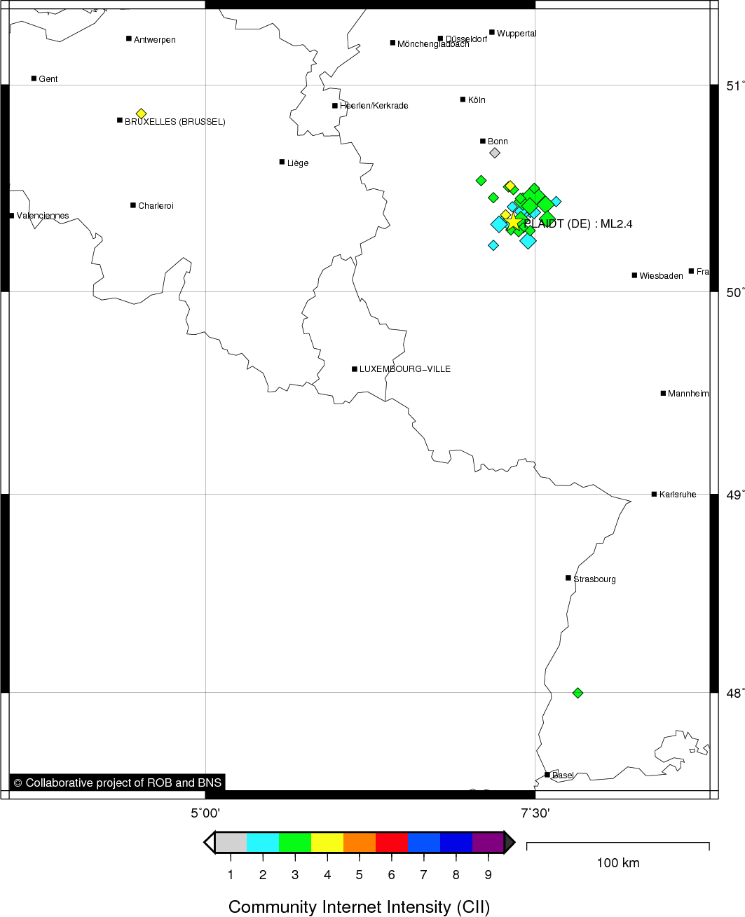
PLAIDT (DE) - 2012-02-21 02:34:57
- Magnitude 2.4
Last update : 2016-11-24 12:15:06 Belgian time
Main parameters
| Date and time |
2012-02-21 02:34:57 UTC
2012-02-21 03:34:57 Belgian time |
| Type | Earthquake |
| Magnitude | ML 2.4 |
| Maximal intensity | III |
| Region | PLAIDT (DE) |
| Epicentral coordinates | 50.338° N, 7.334° E Uncertainty ± 3.0 km |
| Depth of hypocenter | 8.6 ± 2.9 km |
Data source : ROB (Royal Observatory of Belgium)
Location map
Quake measurements
Measurements by the Belgian seismic network
| Station | Epicentral distance (km) |
P-Wave arrival (hh:mm:ss.ss) | S-Wave arrival (hh:mm:ss.ss) | Maximal ground displacement (nm) |
|
|---|---|---|---|---|---|
| Code | Place | ||||
| VIA | VIANDEN | 92 | 02:35:12.86 | 02:35:24.99 | - |
| KLB | KALBORN | 91 | 02:35:12.89 | 02:35:22.55 | - |
| MEMS | MEMBACH | 99 | 02:35:14.17 | 02:35:25.71 | 60.6 |
| WLF | WALFERDANGE | 113 | 02:35:15.76 | 02:35:31.34 | 51.7 |
| EBN | EBEN-EMAEL | 128 | 02:35:18.43 | 02:35:34.17 | 29.9 |
| LCH | LA CHARTREUSE | 127 | 02:35:18.87 | 02:35:34.32 | 51.7 |
| STI | SART TILMAN | 128 | 02:35:19.14 | - | - |
| CLA | CLAVIER | 144 | 02:35:21.03 | 02:35:38.58 | 31.5 |
| RCH | ROCHEFORT | 151 | 02:35:21.85 | 02:35:40.10 | 87.5 |
| GES | GESVES | 160 | 02:35:22.91 | 02:35:42.67 | - |
| MRD | MAREDSOUS | 182 | 02:35:27.19 | 02:35:47.97 | - |
| DOU | DOURBES | 197 | 02:35:27.75 | 02:35:52.43 | 28.2 |
| SKQ | STEENKERQUE | 233 | 02:35:32.98 | - | - |
Macroseismic
Data
| Total number of responses | 74 |
|---|---|
| Intensity I | 6 |
| Intensity II | 20 |
| Intensity III | 43 |
| Intensity IV | 5 |
Attention! The intensities derived from the macroseismic enquiry are raw unverified data.
Map
Data policy
Please read on this notice to learn more about our data policy.